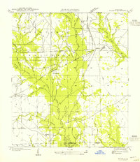
1954 Map of Sugrue
USGS Topo · Published 1954About this map
Kisatchie National Forest dominates this mid-century landscape in western Louisiana, revealing a timber-rich region shaped by the intersection of rail and river. The area is defined by the winding course of Whisky Chitto Creek and its many tributaries, including Maple Branch and Drakes Creek. This survey captures the transition of the local economy, where the Gulf Colorado and Santa Fe railroad line crosses the terrain alongside an extensive network of a Logging Railroad. Small rural centers such as Sugrue and Cravens serve as anchors for the local community, which is supported by institutions like Gravel Hill Sch and Drakes Fork Ch. Further south, the boundary of Vernon Beauregard Parish marks the limit of the quadrangle near Cole Center, providing a clear record of land use and settlement patterns before modern expansion altered these backcountry corridors.
Find a feature on this map
32 named features on this map. Tap any name to fly to it.
Don’t see what you’re looking for? This feature index may not catch every label — zoom into the map to look around manually.
Map Details
Editions of this 1954 Sugrue Map
This is the sole edition of this map. No revisions or reprints were ever made.
Other maps of this area

1941 · Slagle
USGS Topo · 1:62,500

1943 · Leander
USGS Topo · 1:62,500

1944 · Slagle
USGS Topo · 1:62,500

1947 · Ikes
USGS Topo · 1:31,680

1947 · Chasmore
USGS Topo · 1:31,680

1947 · Grant
USGS Topo · 1:31,680

1947 · Sugartown
USGS Topo · 1:31,680

1947 · Sugrue
USGS Topo · 1:31,680

1947 · Pitkin
USGS Topo · 1:31,680

1948 · Grant
USGS Topo · 1:24,000