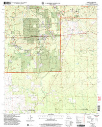
2004 Map of Sugrue
USGS Topo · Published 2005About this map
Kisatchie National Forest dominates the landscape of this region on the border of Vernon and Beauregard Parishes. The map reveals a land defined by its many drainages, including Whisky Chitto Creek, Birds Creek, and Horse Branch, which carve through the wooded terrain. Settlement is sparse, characterized by small communities like Cravens, Sugrue, and Cole Central. The presence of numerous Gravel Pits and a Pumping Sta suggests a local economy tied to resource extraction and utility infrastructure. For genealogists and local historians, the map is a significant record of rural community life, documenting several local houses of worship such as Gravel Hill Ch, Lone Star Ch, and Pine Grove Ch. The map also preserves the locations of family and community resting places, including the Marlow Cem and the Wisby Memorial Cem near the Wisby Memorial Ch.
Find a feature on this map
39 named features on this map. Tap any name to fly to it.
Don’t see what you’re looking for? This feature index may not catch every label — zoom into the map to look around manually.
Map Details
Editions of this 2004 Sugrue Map
This is the sole edition of this map. No revisions or reprints were ever made.
Other maps of this area

1941 · Slagle
USGS Topo · 1:62,500

1943 · Leander
USGS Topo · 1:62,500

1944 · Slagle
USGS Topo · 1:62,500

1947 · Ikes
USGS Topo · 1:31,680

1947 · Chasmore
USGS Topo · 1:31,680

1947 · Grant
USGS Topo · 1:31,680

1947 · Sugartown
USGS Topo · 1:31,680

1947 · Sugrue
USGS Topo · 1:31,680

1947 · Pitkin
USGS Topo · 1:31,680

1948 · Grant
USGS Topo · 1:24,000