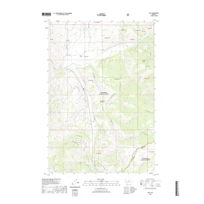
2020 Map of Sula
USGS Topo · Published 2020About this map
Sula and its surrounding valley floor known as Ross Hole anchor this portion of the Bitterroot Valley at the foot of the Anaconda Range. The landscape is a complex intersection of water and historic transit, where the East Fork Bitterroot River meets numerous tributaries like Camp Creek and Reimel Creek. This area serves as a significant mountain gateway, indicated by the convergence of the Nez Perce-Nht (Nee-Me-Poo) and the Continental Divide National Scenic Trail near the Ravalli Co and Beaverhead Co line.
Find a feature on this map
59 named features on this map. Tap any name to fly to it.
Don’t see what you’re looking for? This feature index may not catch every label — zoom into the map to look around manually.
Map Details
Editions of this 2020 Sula Map
This is the sole edition of this map. No revisions or reprints were ever made.
Other maps of this area

1955 · Dillon
USGS Topo · 1:250,000

1956 · Elk City
USGS Topo · 1:250,000

1957 · Dillon
USGS Topo · 1:250,000

1958 · Dillon
USGS Topo · 1:250,000

1960 · Elk City
USGS Topo · 1:250,000

1960 · Piquett Mountain
USGS Topo · 1:62,500

1962 · Dillon
USGS Topo · 1:250,000
1964 · Robbins Gulch
USGS Topo · 1:24,000

1965 · Dillon
USGS Topo · 1:250,000

1965 · Medicine Hot Springs
USGS Topo · 1:24,000