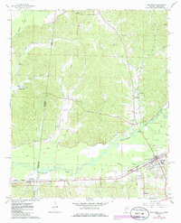
1967 Map of Sulligent
USGS Topo · Published 1986About this map
The Buttahatchee River meanders through the heart of this landscape along the Alabama and Mississippi border, defining the local geography as it flows past the settlements of Sulligent and Gattman. This mid-century survey, updated in the 1980s, highlights a rural economy tied to the land and the Burlington Northern railroad corridor. The area is dotted with numerous small family burial grounds and community landmarks, such as Almon Cem, Pickle Cem, and Sandlin Cem.
Find a feature on this map
36 named features on this map. Tap any name to fly to it.
Don’t see what you’re looking for? This feature index may not catch every label — zoom into the map to look around manually.
Map Details
Editions of this 1967 Sulligent Map
2 editions found
Other maps of this area

1953 · West Point
USGS Topo · 1:250,000

1956 · Tupelo
USGS Topo · 1:250,000

1958 · Tupelo
USGS Topo · 1:250,000

1958 · West Point
USGS Topo · 1:250,000

1963 · West Point
USGS Topo · 1:250,000

1966 · Turon
USGS Topo · 1:24,000

1966 · Greenwood Springs
USGS Topo · 1:24,000

1966 · Amory SE
USGS Topo · 1:24,000

1967 · Sulligent
USGS Topo · 1:24,000

1967 · Beaverton
USGS Topo · 1:24,000