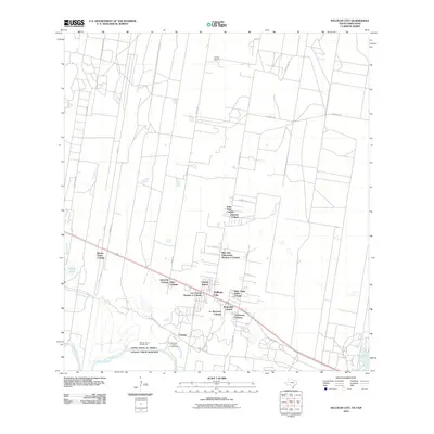
2010 Map of Sullivan City
USGS Topo · Published 2010About this map
The Rio Grande forms the international boundary between the United States and Mexico along the southern edge of this borderland survey. In this region of the Rio Grande Valley, the residential landscape is defined by numerous colonias, representing a distinct pattern of settlement and community development. These communities, such as Valle Vista Colonia, Nina Colonia, and La Hermosa Colonia, are clustered primarily along the primary east-west transportation corridors. Near the river, Cuevitas and specialized river features like Santos Banco Number 95 and Cuevitas Banco Number 96 reflect the hydrological and political history of the meandering waterway. The northern interior transitions into larger land tracts, exemplified by the El Toro Ranch, where the grid of county roads like Sevenmile Rd and County Line Rd stretches across the brush country.
Find a feature on this map
35 named features on this map. Tap any name to fly to it.
Don’t see what you’re looking for? This feature index may not catch every label — zoom into the map to look around manually.
Map Details
Editions of this 2010 Sullivan City Map
This is the sole edition of this map. No revisions or reprints were ever made.
Other maps of this area

1940 · Monte Christo
USGS Topo · 1:62,500

1949 · Mc Allen
USGS Topo · 1:250,000

1954 · McAllen
USGS Topo · 1:250,000

1956 · Garcias
USGS Topo · 1:62,500

1956 · Los Ebanos
USGS Topo · 1:62,500

1957 · Mc Allen
USGS Topo · 1:250,000

1962 · McAllen
USGS Topo · 1:250,000

1963 · La Joya
USGS Topo · 1:24,000

1963 · Citrus City
USGS Topo · 1:24,000
1963 · McCook
USGS Topo · 1:24,000