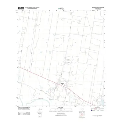
2013 Map of Sullivan City
USGS Topo · Published 2013About this map
The Rio Grande forms the southern boundary of this South Texas landscape, where the international border is defined by river meanders and historic land tracts. Near the riverbanks, the settlement of Cuevitas and the specialized plots of Santos Banco Number 95 and Cuevitas Banco Number 96 reflect the unique cadastral history of the Rio Grande Valley. Further north, Sullivan City serves as the primary hub, organized around a grid of streets like 1st St and 3rd St, while the surrounding terrain is marked by long, narrow property lines extending toward El Toro Ranch. Transport patterns are defined by the parallel paths of Military Rd and Old Military Rd, which follow the natural curve of the river valley. The arid landscape is dotted with ephemeral water features such as Salado Cr, Cobby Lake, and La Joya Lake, illustrating the hydrological character of the region during this era.
Find a feature on this map
36 named features on this map. Tap any name to fly to it.
Don’t see what you’re looking for? This feature index may not catch every label — zoom into the map to look around manually.
Map Details
Editions of this 2013 Sullivan City Map
This is the sole edition of this map. No revisions or reprints were ever made.
Other maps of this area

1940 · Monte Christo
USGS Topo · 1:62,500

1949 · Mc Allen
USGS Topo · 1:250,000

1954 · McAllen
USGS Topo · 1:250,000

1956 · Garcias
USGS Topo · 1:62,500

1956 · Los Ebanos
USGS Topo · 1:62,500

1957 · Mc Allen
USGS Topo · 1:250,000

1962 · McAllen
USGS Topo · 1:250,000

1963 · La Joya
USGS Topo · 1:24,000

1963 · Citrus City
USGS Topo · 1:24,000
1963 · McCook
USGS Topo · 1:24,000