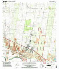
2002 Map of Sullivan City
USGS Topo · Published 2003About this map
Sullivan City and the neighboring community of Cuevitas sit along the northern banks of the Rio Grande Bravo in this early 2000s study of the South Texas borderlands. The landscape reflects a mix of heavy extractive industry and federal conservation efforts, with the Garcia Oil Field and numerous gas wells occupying the northern brush country, while the Lower Rio Grande Valley National Wildlife Refuge preserves the riparian corridor. Local landmarks such as San Guillermo Ch and Benavides Elementary School anchor the residential areas. The map also records several riparian land tracts known as bancos, including La Chicharra Banco No 94 and Cuevitas Banco No 96, which were created by the shifting course of the river over time. Significant gravel operations, including several Gravel Pits and a large Quarry, are visible near the valley's edge.
Find a feature on this map
28 named features on this map. Tap any name to fly to it.
Don’t see what you’re looking for? This feature index may not catch every label — zoom into the map to look around manually.
Map Details
Editions of this 2002 Sullivan City Map
This is the sole edition of this map. No revisions or reprints were ever made.
Other maps of this area

1940 · Monte Christo
USGS Topo · 1:62,500

1949 · Mc Allen
USGS Topo · 1:250,000

1954 · McAllen
USGS Topo · 1:250,000

1956 · Garcias
USGS Topo · 1:62,500

1956 · Los Ebanos
USGS Topo · 1:62,500

1957 · Mc Allen
USGS Topo · 1:250,000

1962 · McAllen
USGS Topo · 1:250,000

1963 · La Joya
USGS Topo · 1:24,000

1963 · Citrus City
USGS Topo · 1:24,000
1963 · McCook
USGS Topo · 1:24,000
Featured Places
- Sullivan City, TX
- La Grulla, TX
- Buena Vista Colonia, TX
- Vales Colonia, Sullivan City
- Benevides Colonia, Sullivan City