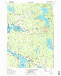
1982 Map of Sullivan
USGS Topo · Published 1983About this map
Taunton Bay and Hog Bay dominate this coastal Maine landscape, where the tides shape the geography of the Sullivan and Franklin shorelines. The 1980s infrastructure shows a region transitioning from its industrial roots, marked by the Maine Central Railroad and numerous quarries, toward a residential and educational hub featuring Mountain View Jr High School and Sumner High Sch. Significant topographic landmarks like Schoodic Mtn and Baker Hill overlook a network of coastal settlements including Sorrento and West Sullivan.
Find a feature on this map
117 named features on this map. Tap any name to fly to it.
Don’t see what you’re looking for? This feature index may not catch every label — zoom into the map to look around manually.
Map Details
Editions of this 1982 Sullivan Map
2 editions found
Other maps of this area

1904 · Mount Desert
USGS Topo · 1:62,500

1904 · Bar Harbor
USGS Topo · 1:62,500

1911 · Ellsworth
USGS Topo · 1:62,500

1930 · Tunk Lake
USGS Topo · 1:48,000

1932 · Tunk Lake
USGS Topo · 1:62,500

1940 · Ellsworth
USGS Topo · 1:62,500

1942 · Bar Harbor
USGS Topo · 1:62,500

1942 · Ellsworth
USGS Topo · 1:62,500

1942 · Mount Desert
USGS Topo · 1:62,500

1942 · Tunk Lake
USGS Topo · 1:62,500