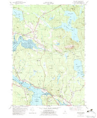
1982 Map of Sullivan
USGS Topo · Published 1983About this map
Sullivan Harbor and the surrounding coastal villages of Hancock County are captured here during a period of established maritime and inland connectivity. The landscape is defined by the intricate waterways of Taunton Bay, Hog Bay, and Donnell Pond, which provided both resources and challenges for local transit. The Maine Central Railroad cuts across the northern terrain, serving settlements like Franklin and East Franklin, while the Hancock-Sullivan Bridge links the peninsula at Waukeag Neck to the western shore.
Find a feature on this map
120 named features on this map. Tap any name to fly to it.
Don’t see what you’re looking for? This feature index may not catch every label — zoom into the map to look around manually.
Map Details
Editions of this 1982 Sullivan Map
2 editions found
Other maps of this area

1904 · Mount Desert
USGS Topo · 1:62,500

1904 · Bar Harbor
USGS Topo · 1:62,500

1911 · Ellsworth
USGS Topo · 1:62,500

1930 · Tunk Lake
USGS Topo · 1:48,000

1932 · Tunk Lake
USGS Topo · 1:62,500

1940 · Ellsworth
USGS Topo · 1:62,500

1942 · Bar Harbor
USGS Topo · 1:62,500

1942 · Ellsworth
USGS Topo · 1:62,500

1942 · Mount Desert
USGS Topo · 1:62,500

1942 · Tunk Lake
USGS Topo · 1:62,500