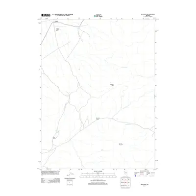
2011 Map of Sulphur
USGS Topo · Published 2011About this map
Sulphur sits in the northwest corner of this Nevada landscape, where the arid environment is defined by its scarce water sources and the high desert topography of the Kamma Mountains. The presence of the Sulphur Landing Strip near the northern border suggests the necessity of aerial access in this isolated territory. Critical water points like Sulphur Springs, Wild Rose Spring, and Barrell Springs provide the vital anchors for movement through the basin. In the central and southern reaches of the map, the terrain rises significantly toward Rosebud Peak, which overlooks the winding path of Rosebud Canyon. This 2011 survey documents a landscape where traditional geographic landmarks like Lander Spring and Rosebud Spring remain the primary points of orientation in a region with very little modern infrastructure beyond the initial settlement area.
Find a feature on this map
10 named features on this map. Tap any name to fly to it.
Don’t see what you’re looking for? This feature index may not catch every label — zoom into the map to look around manually.
Map Details
Editions of this 2011 Sulphur Map
This is the sole edition of this map. No revisions or reprints were ever made.
Other maps of this area

1931 · Lovelock
USGS Topo · 1:250,000

1935 · Lovelock
USGS Topo · 1:250,000

1955 · Lovelock
USGS Topo · 1:250,000

1959 · Lovelock
USGS Topo · 1:250,000
1981 · Rabbithole NE
USGS Topo · 1:24,000
1981 · Sawtooth Knob
USGS Topo · 1:24,000

1981 · Dead Horse Canyon NE
USGS Topo · 1:24,000

1981 · Scossa
USGS Topo · 1:24,000

1981 · Placerites
USGS Topo · 1:24,000
1981 · Sugarloaf Knob
USGS Topo · 1:24,000