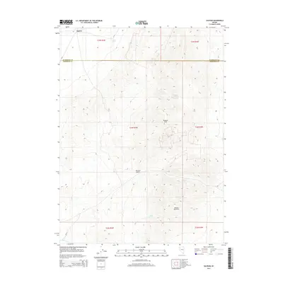
2014 Map of Sulphur
USGS Topo · Published 2014About this map
The high desert terrain of the Kamma Mountains dominates this portion of northwestern Nevada, centered near the border between Humboldt Co and Pershing Co. The small settlement of Sulphur sits along the northern edge of the sheet, situated near the namesake Sulphur Springs. This landscape is defined by its arid hydrology, where vital water sources like Wild Rose Spring, Rosebud Spring, and Lander Spring are scattered across the slopes surrounding Rosebud Peak. In the southwest corner, the drainage of Rabbithole Cr cuts through the basin floor. The geography here is characterized by the transition from the steep relief of Rosebud Canyon to the broad flats typical of the Great Basin's basin-and-range topography. This 2014 survey serves as a precise record of the remote mining and ranching region's physical features and land divisions.
Find a feature on this map
16 named features on this map. Tap any name to fly to it.
Don’t see what you’re looking for? This feature index may not catch every label — zoom into the map to look around manually.
Map Details
Editions of this 2014 Sulphur Map
This is the sole edition of this map. No revisions or reprints were ever made.
Other maps of this area

1931 · Lovelock
USGS Topo · 1:250,000

1935 · Lovelock
USGS Topo · 1:250,000

1955 · Lovelock
USGS Topo · 1:250,000

1959 · Lovelock
USGS Topo · 1:250,000
1981 · Rabbithole NE
USGS Topo · 1:24,000
1981 · Sawtooth Knob
USGS Topo · 1:24,000

1981 · Dead Horse Canyon NE
USGS Topo · 1:24,000

1981 · Scossa
USGS Topo · 1:24,000

1981 · Placerites
USGS Topo · 1:24,000
1981 · Sugarloaf Knob
USGS Topo · 1:24,000