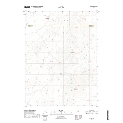
2018 Map of Sulphur
USGS Topo · Published 2018About this map
Sulphur sits at the northern edge of this high-desert landscape, positioned along the historical route of Jungo Rd. This region of the Great Basin is defined by the stark topography of the Kamma Mountains, where water is a scarce but vital resource. The distribution of desert hydrology is meticulously recorded, showing Sulphur Springs in the north and a series of smaller seeps including Wild Rose Spring, Rosebud Spring, and Lander Spring tucked into the upland folds. The terrain is dominated by prominent volcanic and erosional features such as Rosebud Peak and the winding course of Rosebud Canyon. To the southwest, the ephemeral drainage of Rabbit hole Cr cuts through the basin floor, marking a landscape where survival and settlement have long depended on these few dependable water sources scattered across the arid Pershing County range.
Find a feature on this map
17 named features on this map. Tap any name to fly to it.
Don’t see what you’re looking for? This feature index may not catch every label — zoom into the map to look around manually.
Map Details
Editions of this 2018 Sulphur Map
This is the sole edition of this map. No revisions or reprints were ever made.
Other maps of this area

1931 · Lovelock
USGS Topo · 1:250,000

1935 · Lovelock
USGS Topo · 1:250,000

1955 · Lovelock
USGS Topo · 1:250,000

1959 · Lovelock
USGS Topo · 1:250,000
1981 · Rabbithole NE
USGS Topo · 1:24,000
1981 · Sawtooth Knob
USGS Topo · 1:24,000

1981 · Dead Horse Canyon NE
USGS Topo · 1:24,000

1981 · Scossa
USGS Topo · 1:24,000

1981 · Placerites
USGS Topo · 1:24,000
1981 · Sugarloaf Knob
USGS Topo · 1:24,000