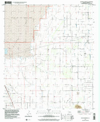
1996 Map of Sulphur Spring
USGS Topo · Published 2002About this map
Willcox Playa dominates the western portion of this landscape, its flat expanses bordering the Willcox Dry Lake Bombing Range. This high-desert terrain in Cochise County reveals a pattern of agricultural and utility development, characterized by numerous wells and several pipelines that traverse the grid. The presence of Kansas Settlement and the eponymous Sulphur Spring indicate pockets of concentrated habitation and vital water sources in an otherwise arid environment. A small Cem near the spring serves as a significant marker for local genealogical research.
Find a feature on this map
13 named features on this map. Tap any name to fly to it.
Don’t see what you’re looking for? This feature index may not catch every label — zoom into the map to look around manually.
Map Details
Editions of this 1996 Sulphur Spring Map
This is the sole edition of this map. No revisions or reprints were ever made.
Other maps of this area

1916 · Pearce
USGS Topo · 1:125,000

1922 · Willcox
USGS Topo · 1:125,000

1926 · Light
USGS Topo · 1:62,500

1926 · Courtland
USGS Topo · 1:62,500

1943 · Dos Cabezas
USGS Topo · 1:62,500

1943 · Cochise
USGS Topo · 1:62,500

1954 · Silver City
USGS Topo · 1:250,000

1955 · Douglas
USGS Topo · 1:250,000

1957 · Dos Cabezas
USGS Topo · 1:62,500

1958 · Silver City
USGS Topo · 1:250,000