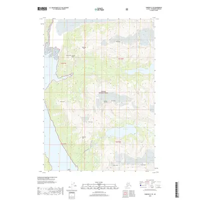
2018 Map of Sumdum A-3 SE
USGS Topo · Published 2018About this map
Tongass National Forest dominates this landscape within the Petersburg Borough, where glacial ice meets the fjords of Southeast Alaska. The northwestern corner is defined by the massive Baird Glacier, which descends toward the coastal waters of Scenery Cove. This area serves as a primary drainage for high alpine peaks and icefields, with Scenery Creek flowing from the elevated Scenery Lake into the cove below. Further south, the Cascade Creek Trail provides a documented route through the dense forest, passing near Falls Lake and the drainage of Swan Lake. The terrain is punctuated by significant summits including the Cosmos Range and distinctively named landmarks like Elephants Head and Fighting John Peak, illustrating the extreme vertical relief between the saltwater shoreline and the glaciated interior peaks.
Find a feature on this map
24 named features on this map. Tap any name to fly to it.
Don’t see what you’re looking for? This feature index may not catch every label — zoom into the map to look around manually.
Map Details
Editions of this 2018 Sumdum A-3 SE Map
This is the sole edition of this map. No revisions or reprints were ever made.
Other maps of this area

1952 · Petersburg
USGS Topo · 1:250,000

1952 · Sumdum
USGS Topo · 1:250,000

1960 · Petersburg
USGS Topo · 1:250,000

1961 · Sumdum A-2
USGS Topo · 1:63,360

1961 · Petersburg D-3
USGS Topo · 1:63,360

1961 · Sumdum A-3
USGS Topo · 1:63,360

1961 · Petersburg D-2
USGS Topo · 1:63,360

1961 · Sumdum
USGS Topo · 1:250,000

1994 · Petersburg D-2
USGS Topo · 1:63,360
1995 · Petersburg D-3
USGS Topo · 1:63,360