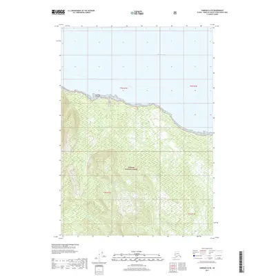
2017 Map of Sumdum A-6 SE
USGS Topo · Published 2017About this map
Tongass National Forest dominates this Alaskan landscape, where the dense timber of the Alexander Archipelago meets the open waters of Frederick Sound. The coastline is marked by complex topographic shifts, notably around the small protrusion of Schooner Island along the northern shore. In the southern interior, the drainage of Gunnuk Cr cuts through the steep slopes, reflecting the heavy glaciation and high precipitation characteristic of this maritime environment. This 2017 survey illustrates the intersection of federal forest management and the rugged shoreline of the Petersburg Borough, providing a clear view of the natural watercourses and elevation contours that have long dictated movement and subsistence in this remote coastal region.
Find a feature on this map
8 named features on this map. Tap any name to fly to it.
Don’t see what you’re looking for? This feature index may not catch every label — zoom into the map to look around manually.
Map Details
Editions of this 2017 Sumdum A-6 SE Map
This is the sole edition of this map. No revisions or reprints were ever made.
Other maps of this area

1948 · Sumdum A-5
USGS Topo · 1:63,360

1948 · Sumdum A-6
USGS Topo · 1:63,360

1948 · Petersburg D-6
USGS Topo · 1:63,360

1948 · Petersburg D-5
USGS Topo · 1:63,360

1951 · Petersburg D-6
USGS Topo · 1:63,360

1952 · Petersburg
USGS Topo · 1:250,000

1952 · Sumdum
USGS Topo · 1:250,000

1960 · Petersburg
USGS Topo · 1:250,000

1961 · Sumdum
USGS Topo · 1:250,000
1994 · Sumdum A-6
USGS Topo · 1:63,360