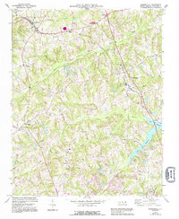
1969 Map of Summerfield
USGS Topo · Published 1994About this map
The rolling landscape of Guilford County north of Greensboro is defined by its transition from agricultural heritage to suburban expansion. Centered on Summerfield, the map reveals a network of rural crossroads and community anchors, including Kings Crossroads and Ogburns Crossroads. The presence of several country churches such as New Hope Ch, Fairview Ch, and Moravia Ch, along with family-named sites like Carlson Dairy, highlights the area's deep-rooted social and economic structure. To the west, the Southern railroad line intersects with Stokesdale, a town whose corporate boundary is clearly delineated. The terrain is deeply carved by water systems, notably the Haw River and the upper reaches of Lake Brandt, which define the drainage patterns for numerous creeks like Reedy Fork Creek and Troublesome Creek. This 1969 survey, updated with 1990s aerial data, documents the region as modern infrastructure began to weave through established farming communities.
Find a feature on this map
43 named features on this map. Tap any name to fly to it.
Don’t see what you’re looking for? This feature index may not catch every label — zoom into the map to look around manually.
Map Details
Editions of this 1969 Summerfield Map
2 editions found

Other maps of this area

1951 · Guilford
USGS Topo · 1:24,000

1951 · Lake Brandt
USGS Topo · 1:24,000

1951 · Greensboro
USGS Topo · 1:24,000

1953 · Winston-Salem
USGS Topo · 1:250,000

1953 · Greensboro
USGS Topo · 1:250,000

1954 · Greensboro
USGS Topo · 1:250,000

1955 · Winston-Salem
USGS Topo · 1:250,000

1962 · Winston-Salem
USGS Topo · 1:250,000

1962 · Greensboro
USGS Topo · 1:250,000

1966 · Greensboro
USGS Topo · 1:250,000