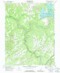
1969 Map of Summersville Dam
USGS Topo · Published 1988About this map
The deep canyons of the Gauley River and Meadow River converge in this West Virginia survey, dominated by the newly formed Summersville Lake following the construction of the Summersville Dam. This 1969 perspective preserves the transition of the landscape from a river-and-road economy to one defined by the massive impoundment. High above the river bend lies the Carnifex Ferry Battlefield State Park, marking a significant Civil War site near the Old Carnifex Ferry Site. Settlement patterns follow the ridges, with nodes at Keslers Cross Lanes and Mount Lookout. Local history is deeply etched into the topography through a network of rural churches like Richmond Chapel and Mount Pleasant Ch, alongside industry-linked routes such as the Chesapeake and Ohio rail line following the river's winding path through the Wilderness district.
Find a feature on this map
41 named features on this map. Tap any name to fly to it.
Don’t see what you’re looking for? This feature index may not catch every label — zoom into the map to look around manually.
Map Details
Editions of this 1969 Summersville Dam Map
3 editions found
Other maps of this area

1889 · Nicholas
USGS Topo · 1:125,000

1891 · Nicholas
USGS Topo · 1:125,000

1897 · Kanawha Falls
USGS Topo · 1:125,000

1900 · Kanawha Falls
USGS Topo · 1:125,000

1901 · Nicholas
USGS Topo · 1:125,000

1901 · Kanawha Falls
USGS Topo · 1:125,000

1908 · Clay
USGS Topo · 1:48,000

1908 · Fayetteville
USGS Topo · 1:48,000

1910 · Clay
USGS Topo · 1:62,500

1910 · Fayetteville
USGS Topo · 1:62,500