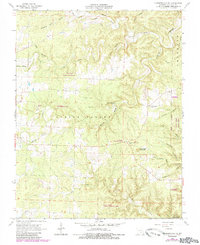
1968 Map of Summersville NE
USGS Topo · Published 1985About this map
Spring Valley defines the topographic character of this portion of Shannon County, where the Ozark Plateau is deeply dissected by a network of drainage systems including Bay Creek and Black Valley Creek. The landscape reflects a mix of conservation and rural community life during the late 1960s, anchored by the Flat Rock State Wildlife Area and the Alley Spring State Forest. Local heritage is concentrated at the intersection of forest and clearing, where Flat Rock Ch and its accompanying Flat Rock Cem stand near the Flat Rock Lookout Tower. A notable geological feature, the Forty Acre Sinkhole, highlights the karst topography prevalent in this region. Further south, the presence of Black Pond Cem and an unnamed Mine provide evidence of early family settlements and small-scale resource extraction embedded within the rugged timberlands.
Find a feature on this map
24 named features on this map. Tap any name to fly to it.
Don’t see what you’re looking for? This feature index may not catch every label — zoom into the map to look around manually.
Map Details
Editions of this 1968 Summersville NE Map
3 editions found
Other maps of this area

1915 · Eminence
USGS Topo · 1:62,500

1917 · Eminence
USGS Topo · 1:62,500

1932 · Cedar Grove
USGS Topo · 1:48,000

1945 · Round Spring
USGS Topo · 1:62,500

1946 · Summersville
USGS Topo · 1:62,500

1947 · Sinkin
USGS Topo · 1:48,000

1948 · Summersville
USGS Topo · 1:62,500

1949 · Round Spring
USGS Topo · 1:62,500

1949 · Rolla
USGS Topo · 1:250,000
1951 · Lewis Hollow
USGS Topo · 1:24,000