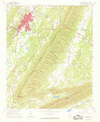
1967 Map of Summerville
USGS Topo · Published 1968About this map
The Central of Georgia railroad tracks cut a definitive path through the heart of Summerville, a community shaped by its position along the Chattooga River and the rising slopes of Taylor Ridge. This late 1960s survey documents the town as a regional hub, featuring the County High Sch, a Hospital, and local broadcast infrastructure like the Radio Tower (WGTA). Beyond the urban core, the landscape transitions into the Chattahoochee National Forest, where the terrain becomes significantly more complex. Genealogists will find a high density of rural landmarks, including the South Carolina Campground Ch and numerous family or community sites such as Oak Hill Cem and Johnson Cem. The map provides a detailed view of the surrounding mountain gaps, including Mack White Gap and the curiously named Tightsqueeze Gap, alongside the rural settlement at Gore.
Find a feature on this map
50 named features on this map. Tap any name to fly to it.
Don’t see what you’re looking for? This feature index may not catch every label — zoom into the map to look around manually.
Map Details
Editions of this 1967 Summerville Map
This is the sole edition of this map. No revisions or reprints were ever made.
Other maps of this area

1886 · Ringgold
USGS Topo · 1:125,000

1886 · Rome
USGS Topo · 1:125,000

1892 · Ringgold
USGS Topo · 1:125,000

1898 · Rome
USGS Topo · 1:125,000

1899 · Rome
USGS Topo · 1:125,000

1904 · Rome
USGS Topo · 1:125,000
1936 · Dougherty Gap
USGS Topo · 1:24,000
1946 · Dougherty Gap
USGS Topo · 1:24,000
1947 · Dougherty Gap
USGS Topo · 1:24,000

1955 · Rome
USGS Topo · 1:250,000