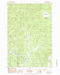
1984 Map of Summit
USGS Topo · Published 1984About this map
Summit sits at a critical high point where the waters divide, with the Luckiamute River flowing northeast and the West Fork Marys River carving a deep valley southward. This area, spanning the intersection of Polk, Lincoln, and Benton counties, is defined by its industrial and burial sites. The presence of several historic graveyards, including the Nashville Grave, Claremont Cem, May Stouts Cem, and Summit Cem, highlights the long-standing family settlements in this timbered landscape. The transportation network is anchored by the Southern Pacific rail line, which skirts the southern portion of the map near Spilde, while an Old R.R. Grade north of Harris Creek suggests earlier logging routes now reverted to the forest. From the peaks of Little Grass Mtn and Goat Knob down to the marshy flats of Wooded Marsh, the map illustrates a rural Oregon community built around the rugged requirements of the Coast Range divide.
Find a feature on this map
45 named features on this map. Tap any name to fly to it.
Don’t see what you’re looking for? This feature index may not catch every label — zoom into the map to look around manually.
Map Details
Editions of this 1984 Summit Map
This is the sole edition of this map. No revisions or reprints were ever made.
Other maps of this area

1921 · Corvallis
USGS Topo · 1:62,500

1939 · Marys Peak
USGS Topo · 1:62,500

1942 · Marys Peak
USGS Topo · 1:62,500

1942 · Corvallis
USGS Topo · 1:62,500

1942 · Valsetz
USGS Topo · 1:62,500

1942 · Dallas
USGS Topo · 1:62,500

1953 · Salem
USGS Topo · 1:250,000

1954 · Salem
USGS Topo · 1:250,000
1956 · Corvallis
USGS Topo · 1:62,500

1956 · Valsetz
USGS Topo · 1:62,500