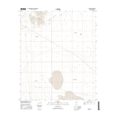
2017 Map of Summit
USGS Topo · Published 2017About this map
Summit Hills and the southern reaches of the Animas Valley define this landscape in Hidalgo County, where water management is the primary marker of human activity. The settlement of Summit sits at the head of Railroad Wash, illustrating how early infrastructure followed natural drainage patterns in the high desert. A network of ranch roads, including Double M Ranch Rd and Rafter J L Ranch Rd, connects scattered livestock watering points like High Lonesome Tank and Three Mills Tank. This 2017 survey reveals a ranching economy still reliant on these isolated improvements, with named landmarks like Summit Tank and Road 4 Tank serving as essential nodes in the arid terrain. The map provides a precise view of public land survey sections and ranch boundaries that have structured this corner of New Mexico for generations.
Find a feature on this map
18 named features on this map. Tap any name to fly to it.
Don’t see what you’re looking for? This feature index may not catch every label — zoom into the map to look around manually.
Map Details
Editions of this 2017 Summit Map
This is the sole edition of this map. No revisions or reprints were ever made.
Other maps of this area

1917 · San Simon
USGS Topo · 1:125,000

1926 · Orange Butte
USGS Topo · 1:62,500

1950 · San Simon
USGS Topo · 1:62,500

1951 · San Simon
USGS Topo · 1:62,500

1954 · Silver City
USGS Topo · 1:250,000

1958 · Silver City
USGS Topo · 1:250,000

1959 · Canador Peak
USGS Topo · 1:62,500

1960 · Duncan
USGS Topo · 1:62,500

1962 · Silver City
USGS Topo · 1:250,000
1962 · San Simon
USGS Topo · 1:62,500