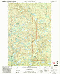
1999 Map of Summit Lake
USGS Topo · Published 2004About this map
Ottawa National Forest and the McCormick Wilderness dominate this Upper Peninsula landscape at the boundary of Baraga and Marquette counties. The map captures a transition in forest management and preservation at the close of the 20th century, where the primitive Upper Baraga Lake Trail and Lower Baraga Lake Trail provide the only significant interior access. The hydrology is complex, featuring the headwaters of the West Branch Huron River and the Peshekee River, which thread through a dense network of glacial lakes including Summit Lake, White Deer Lake, and Lake Alice. Remote landmarks like the Communication Tower and a solitary Gravel Pit near the Michigan ME Boundary contrast with the largely untouched wilderness character of Craig Lake State Park in the southwest corner.
Find a feature on this map
39 named features on this map. Tap any name to fly to it.
Don’t see what you’re looking for? This feature index may not catch every label — zoom into the map to look around manually.
Map Details
Editions of this 1999 Summit Lake Map
This is the sole edition of this map. No revisions or reprints were ever made.
Other maps of this area

1954 · Huron Mountain
USGS Topo · 1:62,500

1954 · Skanee
USGS Topo · 1:62,500

1955 · Champion
USGS Topo · 1:24,000

1955 · Champion
USGS Topo · 1:62,500

1956 · Three Lakes
USGS Topo · 1:24,000

1956 · Michigamme
USGS Topo · 1:62,500

1956 · Michigamme
USGS Topo · 1:24,000

1958 · Marquette
USGS Topo · 1:250,000

1958 · Iron River
USGS Topo · 1:250,000

1960 · Iron River
USGS Topo · 1:250,000