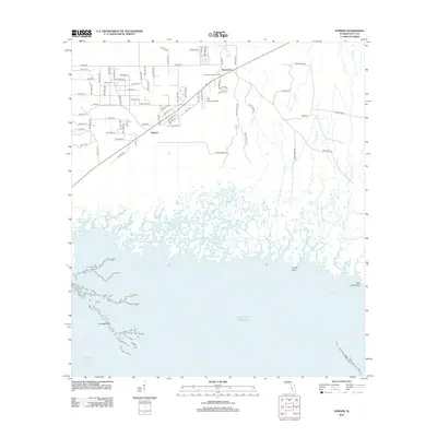
2012 Map of Sumner
USGS Topo · Published 2012About this map
The settlement of Rosewood sits in the northern reaches of this coastal Levy County landscape, a region defined by the complex transition from pine flatwoods to the brackish marshes of Waccasassa Bay. This 2012 survey illustrates a landscape where human infrastructure like The Cedars Airfield and the Suwannee Lookout Tower meets an intricate network of tidal creeks including Jacks Cr and Kelly Cr. To the southwest, the community of Sumner is positioned near the edge of the wetlands, where the terrestrial road grid gives way to the open waters of the Gulf of Mexico. The coastal geography is particularly detailed, showing maritime features such as Corrigan Reef, Big Stake Gap, and the South Bar Channel. For those tracing local heritage, the inclusion of Shiloh Cem and family-named roads like Hodge Rd and Hodges Rd provides specific points of interest within the rural Levy County interior.
Find a feature on this map
94 named features on this map. Tap any name to fly to it.
Don’t see what you’re looking for? This feature index may not catch every label — zoom into the map to look around manually.
Map Details
Editions of this 2012 Sumner Map
This is the sole edition of this map. No revisions or reprints were ever made.
Other maps of this area

1954 · Otter Creek
USGS Topo · 1:24,000

1954 · Chiefland SW
USGS Topo · 1:24,000

1954 · East Pass
USGS Topo · 1:24,000

1954 · Gainesville
USGS Topo · 1:250,000

1955 · Seahorse Key
USGS Topo · 1:24,000

1955 · Cedar Key
USGS Topo · 1:24,000

1955 · Withlacoochee Bay
USGS Topo · 1:24,000

1955 · Waccasassa Bay
USGS Topo · 1:24,000

1955 · Sumner
USGS Topo · 1:24,000

1958 · Gainesville
USGS Topo · 1:250,000