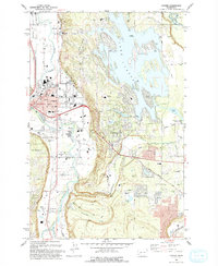
1993 Map of Sumner
USGS Topo · Published 1993About this map
Lake Tapps dominates the eastern landscape, its complex shoreline dotted with recreational sites like Allan Yorke City Park and the distinctive Hole in the Wall passage. To the west, the White River and Puyallup River valleys define the lowlands, where the city of Sumner serves as a central hub. This early 1990s revision shows a region balancing suburban growth in Bonney Lake with its agricultural and industrial foundations. Local history is physically anchored by the Connells Prairie Battle Historical Marker and the Muckleshoot Indian Reservation boundary. Educational landmarks are prominent, including Maple Lawn Sch and Daffodil Valley Sch, while the presence of a Fish Hatchery and numerous Borrow Pits reflects the area's active management of natural resources and infrastructure.
Find a feature on this map
50 named features on this map. Tap any name to fly to it.
Don’t see what you’re looking for? This feature index may not catch every label — zoom into the map to look around manually.
Map Details
Editions of this 1993 Sumner Map
This is the sole edition of this map. No revisions or reprints were ever made.
Other maps of this area

1897 · Tacoma
USGS Topo · 1:125,000

1900 · Tacoma
USGS Topo · 1:125,000

1941 · Tacoma South
USGS Topo · 1:62,500

1942 · Lake Tapps
USGS Topo · 1:62,500

1944 · Lake Tapps
USGS Topo · 1:62,500

1944 · Tacoma South
USGS Topo · 1:62,500

1949 · Black Diamond
USGS Topo · 1:24,000

1949 · Poverty Bay
USGS Topo · 1:24,000

1949 · Auburn
USGS Topo · 1:24,000

1956 · Orting
USGS Topo · 1:24,000