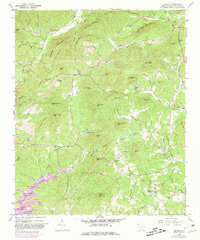
1961 Map of Sumter West
USGS Topo · Published 1981About this map
Horse Gap Mountain and Wadakoe Mountain dominate this corner of the Blue Ridge foothills, where the terrain drops sharply toward the expanding waters of Keowee Lake. The landscape is a network of ridges and deep drainage basins, characterized by numerous peaks such as Sharp Top Mtn and Pink Mtn. The 1981 revisions highlight the rising water levels in the southwest, particularly within Keowee Toxaway State Park, as the Crow Creek arm of the reservoir encroaches on older topographic contours.
Find a feature on this map
91 named features on this map. Tap any name to fly to it.
Don’t see what you’re looking for? This feature index may not catch every label — zoom into the map to look around manually.
Map Details
Editions of this 1961 Sumter West Map
This is the sole edition of this map. No revisions or reprints were ever made.
Other maps of this area

1938 · Hagood
USGS Topo · 1:62,500

1941 · Spartanburg
USGS Topo · 1:250,000

1942 · Camden
USGS Topo · 1:125,000

1943 · Eastover
USGS Topo · 1:62,500

1946 · Sumter
USGS Topo · 1:62,500

1953 · Poinsett State Park
USGS Topo · 1:24,000

1953 · Wedgefield
USGS Topo · 1:24,000

1953 · Rembert
USGS Topo · 1:24,000

1953 · Spartanburg
USGS Topo · 1:250,000

1954 · Augusta
USGS Topo · 1:250,000