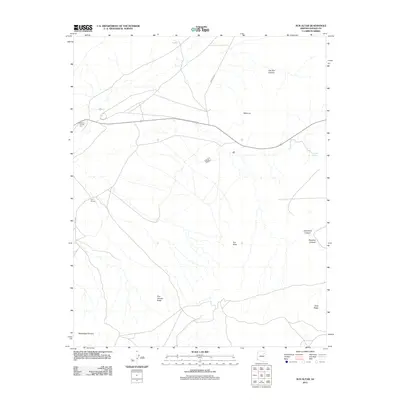
2011 Map of Sun Altar
USGS Topo · Published 2011About this map
Polacca Trading Post and the nearby Five Houses settlement anchor this arid landscape in the Hopi and Navajo lands of northern Arizona. The terrain is defined by a network of seasonal drainages and deep incisions, notably Owl Box Canyon and the parallel paths of Bluebird Canyon and Snowbird Canyon in the southeast. Significant elevation markers like Five Houses Butte and Gray Ridge rise above the washes, while Sactone Spring provides a critical water source in a region where Wepo Wash channels intermittent flow. Cultural locations such as Mots'ovi and Sun Altar are reached by local roads like Indian Rte 60 and BIA 16 Rd, which cut across the high desert plateaus and the broad shelf of Windswept Terrace.
Find a feature on this map
14 named features on this map. Tap any name to fly to it.
Don’t see what you’re looking for? This feature index may not catch every label — zoom into the map to look around manually.
Map Details
Editions of this 2011 Sun Altar Map
This is the sole edition of this map. No revisions or reprints were ever made.
Other maps of this area

1883 · Tusayan
USGS Topo · 1:250,000

1886 · Tusayan
USGS Topo · 1:250,000

1947 · Flagstaff
USGS Topo · 1:250,000

1954 · Flagstaff
USGS Topo · 1:250,000

1958 · Flagstaff
USGS Topo · 1:250,000

1960 · Flagstaff
USGS Topo · 1:250,000

1962 · Flagstaff
USGS Topo · 1:250,000

1966 · White Cone
USGS Topo · 1:62,500

1966 · Egloffstein Butte
USGS Topo · 1:62,500
1966 · Keams Canyon
USGS Topo · 1:62,500