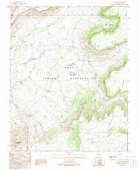
1991 Map of Sun Altar
USGS Topo · Published 1991About this map
The Hopi Indian Reservation landscape is defined here by the dramatic escarpments of First Mesa and Antelope Mesa, separated by a complex network of seasonal drainages. In this arid environment, the placement of infrastructure is tied closely to the topography, as seen with the Hopi High Sch and its adjacent Athletic Fields situated on the higher ground of the mesa plateau. Water management is a central theme, evidenced by numerous check dams and named water sources like Sun Alter Spring and Jeddito Spring that have historically sustained life in this high desert.
Find a feature on this map
22 named features on this map. Tap any name to fly to it.
Don’t see what you’re looking for? This feature index may not catch every label — zoom into the map to look around manually.
Map Details
Editions of this 1991 Sun Altar Map
This is the sole edition of this map. No revisions or reprints were ever made.
Other maps of this area

1883 · Tusayan
USGS Topo · 1:250,000

1886 · Tusayan
USGS Topo · 1:250,000

1947 · Flagstaff
USGS Topo · 1:250,000

1954 · Flagstaff
USGS Topo · 1:250,000

1958 · Flagstaff
USGS Topo · 1:250,000

1960 · Flagstaff
USGS Topo · 1:250,000

1962 · Flagstaff
USGS Topo · 1:250,000

1966 · White Cone
USGS Topo · 1:62,500

1966 · Egloffstein Butte
USGS Topo · 1:62,500
1966 · Keams Canyon
USGS Topo · 1:62,500