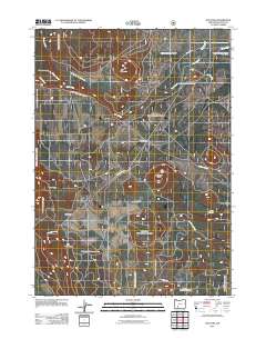
2011 Map of Sun Pass
USGS Topo · Published 2011About this map
Sun Pass and Sun Mountain anchor this high-elevation landscape in Klamath County, where the transition between volcanic buttes and meadow valleys is marked by a complex network of forest development roads. The topography is defined by prominent rises like Dry Butte and Boundary Butte, which overlook the headwaters of Sand Creek and the neighboring Cavern Creek. A notable intersection of geographic and human activity occurs at Sand Creek Junction, where mountain routes converge near the upper reaches of the Sand Creek Canal.
Find a feature on this map
16 named features on this map. Tap any name to fly to it.
Don’t see what you’re looking for? This feature index may not catch every label — zoom into the map to look around manually.
Map Details
Editions of this 2011 Sun Pass Map
This is the sole edition of this map. No revisions or reprints were ever made.
Other maps of this area

1889 · Klamath
USGS Topo · 1:250,000

1891 · Ashland
USGS Topo · 1:250,000

1893 · Ashland
USGS Topo · 1:250,000

1894 · Klamath
USGS Topo · 1:250,000

1897 · Ashland
USGS Topo · 1:250,000

1955 · Pelican Butte
USGS Topo · 1:62,500

1955 · Klamath Falls
USGS Topo · 1:250,000

1955 · Medford
USGS Topo · 1:250,000

1957 · Medford
USGS Topo · 1:250,000

1957 · Chiloquin
USGS Topo · 1:62,500