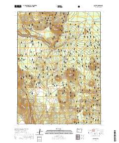
2020 Map of Sun Pass
USGS Topo · Published 2020About this map
Crater Lake National Park occupies the northwestern corner of this territory, where the terrain rises toward Sand Ridge and the volcanic peaks of the High Cascades. This landscape, managed largely as part of the Winema National Forest, is defined by its extensive network of seasonal access routes and specialized winter trails. The presence of routes such as Diamond Lake-Snomo (Snow), Pinnacles (Snow), and Sun Pass Run (Snow) reflects the area's importance for timber management and alpine recreation. High points like Dry Butte and Boundary Butte overlook a complex drainage system including Jackson Creek (Snow) and the Sand Cr Canal. In the southern reaches, Sun Mtn stands near Sun Pass, while natural water sources like Egan Springs provide vital points of interest in this forested high-altitude environment.
Find a feature on this map
37 named features on this map. Tap any name to fly to it.
Don’t see what you’re looking for? This feature index may not catch every label — zoom into the map to look around manually.
Map Details
Editions of this 2020 Sun Pass Map
This is the sole edition of this map. No revisions or reprints were ever made.
Other maps of this area

1889 · Klamath
USGS Topo · 1:250,000

1891 · Ashland
USGS Topo · 1:250,000

1893 · Ashland
USGS Topo · 1:250,000

1894 · Klamath
USGS Topo · 1:250,000

1897 · Ashland
USGS Topo · 1:250,000

1955 · Pelican Butte
USGS Topo · 1:62,500

1955 · Klamath Falls
USGS Topo · 1:250,000

1955 · Medford
USGS Topo · 1:250,000

1957 · Medford
USGS Topo · 1:250,000

1957 · Chiloquin
USGS Topo · 1:62,500