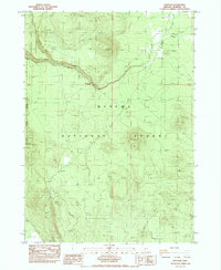
1985 Map of Sun Pass
USGS Topo · Published 1985About this map
Crater Lake National Park and Winema National Forest meet in this mid-1980s topographical study, defined by the transition between volcanic highlands and timbered forest. The landscape is dominated by notable geological formations including the Sand Creek Pinnacles and several volcanic summits such as Dry Butte and Sun Mountain. The terrain is deeply carved by Sand Creek, which flows past a designated Viewpoint overlooking the rugged canyon topography.
Find a feature on this map
17 named features on this map. Tap any name to fly to it.
Don’t see what you’re looking for? This feature index may not catch every label — zoom into the map to look around manually.
Map Details
Editions of this 1985 Sun Pass Map
This is the sole edition of this map. No revisions or reprints were ever made.
Other maps of this area

1889 · Klamath
USGS Topo · 1:250,000

1891 · Ashland
USGS Topo · 1:250,000

1893 · Ashland
USGS Topo · 1:250,000

1894 · Klamath
USGS Topo · 1:250,000

1897 · Ashland
USGS Topo · 1:250,000

1955 · Pelican Butte
USGS Topo · 1:62,500

1955 · Klamath Falls
USGS Topo · 1:250,000

1955 · Medford
USGS Topo · 1:250,000

1957 · Medford
USGS Topo · 1:250,000

1957 · Chiloquin
USGS Topo · 1:62,500