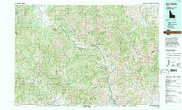
1992 Map of Sun Valley
USGS Topo · Published 1993About this map
Sun Valley and the surrounding high-altitude landscapes of central Idaho are detailed in this early 1990s study, which highlights the region's evolution from a mining frontier to a premier recreation destination. The settlement pattern follows the Big Wood River valley, connecting the population centers of Hailey, Ketchum, and the resort community of Elkhorn. The industrial legacy of the area is still evident through the location of the Triumph Mine and Phi Kappa Mines, while the infrastructure for modern access is marked by Friedman Memorial Airport and smaller strips like Smiley Creek Airport.
Find a feature on this map
45 named features on this map. Tap any name to fly to it.
Don’t see what you’re looking for? This feature index may not catch every label — zoom into the map to look around manually.
Map Details
Editions of this 1992 Sun Valley Map
2 editions found
Other maps of this area

1891 · Bear Valley
USGS Topo · 1:125,000

1892 · Camas Prairie
USGS Topo · 1:125,000

1893 · Bear Valley
USGS Topo · 1:125,000

1893 · Camas Prairie
USGS Topo · 1:125,000

1894 · Rocky Bar
USGS Topo · 1:125,000

1895 · Hailey
USGS Topo · 1:125,000

1897 · Hailey
USGS Topo · 1:125,000

1900 · Sawtooth
USGS Topo · 1:125,000

1919 · Custer
USGS Topo · 1:125,000

1922 · Custer
USGS Topo · 1:125,000