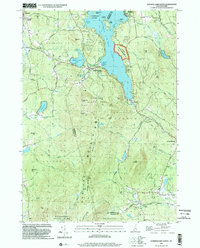
1998 Map of Sunapee Lake South
USGS Topo · Published 2002About this map
Sunapee Mountain and the southern reaches of Sunapee Lake dominate this New Hampshire landscape, where the intersection of natural conservation and historic transportation is evident. The western shoreline of the lake includes the John Hay National Wildlife Refuge and State Park Beach, while an Old Railroad Grade traces a path through the hills near Mountainview Lake. This corridor once connected the lakeside hamlets of Edgemont and Sunapee Station, illustrating the region's late 19th-century reliance on rail for both industry and tourism.
Find a feature on this map
83 named features on this map. Tap any name to fly to it.
Don’t see what you’re looking for? This feature index may not catch every label — zoom into the map to look around manually.
Map Details
Editions of this 1998 Sunapee Lake South Map
This is the sole edition of this map. No revisions or reprints were ever made.
Other maps of this area

1902 · Sunapee
USGS Topo · 1:62,500

1905 · Sunapee
USGS Topo · 1:62,500

1907 · Sunapee
USGS Topo · 1:62,500

1926 · Hillsboro
USGS Topo · 1:62,500

1928 · Mount Kearsarge
USGS Topo · 1:62,500

1929 · Hillsboro
USGS Topo · 1:62,500

1930 · Lovewell Mountain
USGS Topo · 1:62,500

1931 · Mount Kearsarge
USGS Topo · 1:62,500

1942 · Lovewell Mountain
USGS Topo · 1:62,500

1949 · Portland
USGS Topo · 1:250,000