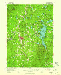
1955 Map of Sunapee
USGS Topo · Published 1958About this map
The waters of Little Sunapee Lake and the expansive Sunapee Harbor define the central character of this Sullivan County landscape during the mid-1950s. The settlement at Newport serves as a primary hub, while the shoreline of Lake Sunapee is dotted with distinct summer communities and landings such as Burkehaven, Blodgett Landing, and Soo Nipi Park. The presence of the Boston and Maine railroad line and the Dartmouth College Highway underscores the region's importance as a New England transit corridor during this era.
Find a feature on this map
160 named features on this map. Tap any name to fly to it.
Don’t see what you’re looking for? This feature index may not catch every label — zoom into the map to look around manually.
Map Details
Editions of this 1955 Sunapee Map
3 editions found
Other maps of this area

1902 · Sunapee
USGS Topo · 1:62,500

1905 · Sunapee
USGS Topo · 1:62,500

1906 · Hanover
USGS Topo · 1:62,500

1907 · Sunapee
USGS Topo · 1:62,500

1908 · Hanover
USGS Topo · 1:62,500

1926 · Hillsboro
USGS Topo · 1:62,500

1926 · Claremont
USGS Topo · 1:62,500

1927 · Bellows Falls
USGS Topo · 1:48,000

1927 · Cardigan
USGS Topo · 1:62,500

1927 · Mascoma
USGS Topo · 1:62,500