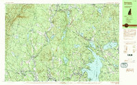
1984 Map of Sunapee
USGS Topo · Published 1984About this map
Lake Sunapee and its intricate northern shoreline anchor this mid-1980s topographical survey of Sullivan County. The map details a transition from the lakeside communities of Sunapee, Georges Mills, and Burkehaven to the elevated, timbered ridges of Croydon Mountain and Grantham Mountain. Settlement patterns follow the valleys, with older village centers like Croydon Four Corners and North Newport connected by a network of rural roads and the Old Railroad Bed.
Find a feature on this map
113 named features on this map. Tap any name to fly to it.
Don’t see what you’re looking for? This feature index may not catch every label — zoom into the map to look around manually.
Map Details
Editions of this 1984 Sunapee Map
2 editions found
Other maps of this area

1902 · Sunapee
USGS Topo · 1:62,500

1905 · Sunapee
USGS Topo · 1:62,500

1906 · Hanover
USGS Topo · 1:62,500

1907 · Sunapee
USGS Topo · 1:62,500

1908 · Hanover
USGS Topo · 1:62,500

1926 · Claremont
USGS Topo · 1:62,500

1927 · Cardigan
USGS Topo · 1:62,500

1927 · Mascoma
USGS Topo · 1:62,500

1928 · Mount Kearsarge
USGS Topo · 1:62,500

1929 · Claremont
USGS Topo · 1:62,500