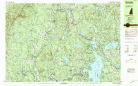
1984 Map of Sunapee
USGS Topo · Published 1984About this map
Sunapee Lake dominates the eastern portion of this Sullivan County landscape, its irregular shoreline punctuated by Sunapee Harbor, Hedgehog Cove, and Dunning Point. In the mid-1980s, this region shows a transition between industrial and recreational land use, where the Sugar River flows west toward Guild and Newport, historically powering local mills. The rugged interior is defined by Croydon Mountain and the Gile Memorial Forest, creating a mosaic of conservation land and small settlements like Georges Mills. Evidence of the area's geological and transportation history is visible in features like Mica Mine Hill and the route of the Boston and Maine Railroad passing through the southern valley. Unique natural features like the Philbrick-Cricenti Bog and numerous smaller bodies of water, including Perkins Pond and Stocker Pond, illustrate the post-glacial topography characteristic of the New Hampshire highlands.
Find a feature on this map
95 named features on this map. Tap any name to fly to it.
Don’t see what you’re looking for? This feature index may not catch every label — zoom into the map to look around manually.
Map Details
Editions of this 1984 Sunapee Map
2 editions found
Other maps of this area

1902 · Sunapee
USGS Topo · 1:62,500

1905 · Sunapee
USGS Topo · 1:62,500

1906 · Hanover
USGS Topo · 1:62,500

1907 · Sunapee
USGS Topo · 1:62,500

1908 · Hanover
USGS Topo · 1:62,500

1926 · Claremont
USGS Topo · 1:62,500

1927 · Cardigan
USGS Topo · 1:62,500

1927 · Mascoma
USGS Topo · 1:62,500

1928 · Mount Kearsarge
USGS Topo · 1:62,500

1929 · Claremont
USGS Topo · 1:62,500