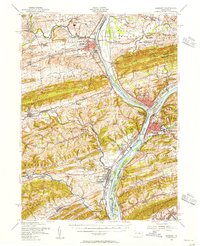
1953 Map of Sunbury
USGS Topo · Published 1956About this map
Lewisburg and Sunbury serve as the primary hubs in this mid-century portrait of the Susquehanna valley, where the confluence of the West and North branches defines the regional geography. Educational and institutional landmarks anchor the landscape, including Bucknell University and the U S Penitentiary near the riverbanks. The map captures a sophisticated network of mid-century infrastructure, from the Shamokin Dam to the complex rail alignments of the Reading, Pennsylvania, and Delaware Lackawanna and Western railroads.
Find a feature on this map
107 named features on this map. Tap any name to fly to it.
Don’t see what you’re looking for? This feature index may not catch every label — zoom into the map to look around manually.
Map Details
Editions of this 1953 Sunbury Map
3 editions found
Other maps of this area

1892 · Lykens
USGS Topo · 1:62,500

1892 · Shamokin
USGS Topo · 1:62,500

1893 · Sunbury
USGS Topo · 1:62,500

1893 · Lykens
USGS Topo · 1:62,500

1893 · Shamokin
USGS Topo · 1:62,500

1893 · Millersburg
USGS Topo · 1:62,500

1907 · Millerstown
USGS Topo · 1:62,500

1921 · Williamsport
USGS Topo · 1:48,000

1923 · Williamsport
USGS Topo · 1:62,500

1924 · Milton
USGS Topo · 1:62,500