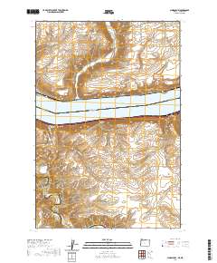
2020 Map of Sundale NW
USGS Topo · Published 2020About this map
Lake Umatilla dominates the central corridor of this landscape, marking the interstate boundary between Klickitat County, Washington, and Gilliam County, Oregon. The topography is defined by the high plateaus and deep drainage incisions typical of the Columbia River basin, with named corridors such as Swanson Canyon and Phillippi Canyon cutting through the terrain toward the water. On the Washington side, the small settlement of Bates sits near the shoreline, while the Oregon side features the broad expanse of Blalock Flat. Local transport and access are dictated by the steep relief, shown through routes like Goodnoe Station Rd and Old Hwy 8. The confluence of the John Day River in the southwest corner highlights the complex hydrologic network that has shaped this region's development and natural borders.
Find a feature on this map
24 named features on this map. Tap any name to fly to it.
Don’t see what you’re looking for? This feature index may not catch every label — zoom into the map to look around manually.
Map Details
Editions of this 2020 Sundale NW Map
This is the sole edition of this map. No revisions or reprints were ever made.
Other maps of this area

1916 · Arlington
USGS Topo · 1:125,000

1953 · The Dalles
USGS Topo · 1:250,000

1956 · The Dalles
USGS Topo · 1:250,000

1957 · The Dalles
USGS Topo · 1:250,000

1957 · Wasco
USGS Topo · 1:62,500

1957 · Satus Pass
USGS Topo · 1:62,500

1964 · Turner Butte
USGS Topo · 1:24,000

1964 · Mc Donald
USGS Topo · 1:24,000

1965 · Goodnoe Hills
USGS Topo · 1:24,000
1965 · Dot
USGS Topo · 1:24,000