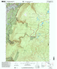
1997 Map of Sunderland
USGS Topo · Published 2000About this map
The Batten Kill river valley anchors this map of the Green Mountains, showcasing a landscape where high-altitude wilderness meets pockets of human settlement. While the town of Sunderland sits in the northwest, much of the terrain is defined by the Green Mountain National Forest and the protected Lye Brook Wilderness. This 1990s revision reveals the intricate network of hiking routes including the Long Trail and Appalachian Trail, which traverse ridges like Winhall Spur and pass remote waypoints such as Story Spring Shelter and Caughnawaga Shelter. Evidence of historic mountain life and industry appears at Fayville and Kelley Stand, alongside a Gravel Pit near the river. The map details a complex hydrography of ponds and brooks, from Bourn Pond in the northeast to the Glastenbury River in the south, reflecting the rugged, water-rich environment of southern Vermont.
Find a feature on this map
51 named features on this map. Tap any name to fly to it.
Don’t see what you’re looking for? This feature index may not catch every label — zoom into the map to look around manually.
Map Details
Editions of this 1997 Sunderland Map
This is the sole edition of this map. No revisions or reprints were ever made.
Other maps of this area

1889 · Wilmington
USGS Topo · 1:62,500

1891 · Wilmington
USGS Topo · 1:62,500

1894 · Londonderry
USGS Topo · 1:62,500

1894 · Equinox
USGS Topo · 1:62,500

1896 · Equinox
USGS Topo · 1:62,500

1898 · Bennington
USGS Topo · 1:62,500

1899 · Londonderry
USGS Topo · 1:62,500

1899 · Wilmington
USGS Topo · 1:62,500

1900 · Taconic
USGS Topo · 1:125,000

1900 · Equinox
USGS Topo · 1:62,500