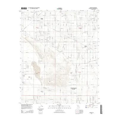
2015 Map of Sunfair
USGS Topo · Published 2015About this map
Copper Mtn dominates the central landscape of this Mojave Desert quadrangle, anchoring a region defined by residential expansion and desert aviation. To the south, the northern reaches of Twentynine Palms are visible along the Twentynine Palms Hwy corridor, featuring Copper Mtn Community College. The map documents several distinct desert communities including Sunfair Heights, Desert Heights, and Coyote Valley, which are connected by a grid of named streets like Sunview Ave and Coyote Valley Rd. The dry bed of Coyote Lake and the Roy Williams Airport highlight the area's specific use of the arid terrain for transportation and infrastructure. This era of the High Desert shows a transition from isolated settlements to more structured suburban planning while maintaining the characteristic open space of the Mojave Desert.
Find a feature on this map
187 named features on this map. Tap any name to fly to it.
Don’t see what you’re looking for? This feature index may not catch every label — zoom into the map to look around manually.
Map Details
Editions of this 2015 Sunfair Map
This is the sole edition of this map. No revisions or reprints were ever made.
Other maps of this area

1953 · San Bernardino
USGS Topo · 1:250,000

1955 · Goat Mountain
USGS Topo · 1:24,000

1955 · Deadman Lake SE
USGS Topo · 1:24,000

1955 · Deadman Lake SW
USGS Topo · 1:24,000

1955 · Twentynine Palms
USGS Topo · 1:24,000

1955 · Twentynine Palms
USGS Topo · 1:62,500

1955 · Emerson Lake
USGS Topo · 1:62,500
1955 · Deadman Lake
USGS Topo · 1:62,500

1955 · Joshua Tree
USGS Topo · 1:62,500

1956 · San Bernardino
USGS Topo · 1:250,000