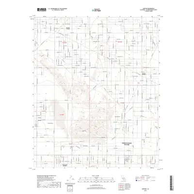
2018 Map of Sunfair
USGS Topo · Published 2018About this map
Twentynine Palms and its northern outskirts characterize this landscape in the high desert, where residential developments meet the sprawling Mojave Desert. The area is marked by distinct settlements and residential enclaves such as Sunfair Heights, Desert Heights, and Panorama Heights, reflecting the modern expansion of these communities within the arid terrain. Copper Mtn College stands as a central institutional landmark just south of the prominent Copper Mtn massif. A dense grid of named roads, many with celestial and historical names like Venus St, Mars St, and Giant Rock Rd, crisscrosses Coyote Valley, indicating the surveyed and subdivided nature of the land. This spatial organization provides a clear view of how high-desert habitation is structured around natural landforms and the regional transportation corridors connecting these dispersed neighborhoods.
Find a feature on this map
130 named features on this map. Tap any name to fly to it.
Don’t see what you’re looking for? This feature index may not catch every label — zoom into the map to look around manually.
Map Details
Editions of this 2018 Sunfair Map
This is the sole edition of this map. No revisions or reprints were ever made.
Other maps of this area

1953 · San Bernardino
USGS Topo · 1:250,000

1955 · Goat Mountain
USGS Topo · 1:24,000

1955 · Deadman Lake SE
USGS Topo · 1:24,000

1955 · Deadman Lake SW
USGS Topo · 1:24,000

1955 · Twentynine Palms
USGS Topo · 1:24,000

1955 · Twentynine Palms
USGS Topo · 1:62,500

1955 · Emerson Lake
USGS Topo · 1:62,500
1955 · Deadman Lake
USGS Topo · 1:62,500

1955 · Joshua Tree
USGS Topo · 1:62,500

1956 · San Bernardino
USGS Topo · 1:250,000