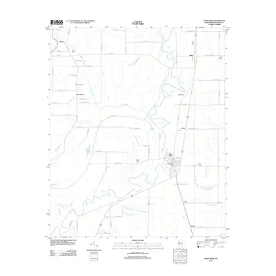
2012 Map of Sunflower
USGS Topo · Published 2012About this map
The Big Sunflower River defines the lower half of this landscape, meandering through Sunflower County alongside wetlands like Turkeyfoot Brake. The town of Sunflower stands as the central hub of this agricultural region, surrounded by smaller communities and crossroads such as Pine Land, Dwyer, and Pentecost. To the north, the settlement of Blaine is situated near the New Hope Cem, while Steiner marks the northwestern corner of the quadrangle. The map is heavily detailed with family and local history markers, particularly seen in the distribution of community burial grounds like Willing Worker Cem and Sixteenth Section Cem. The grid of rural roads, including Blaine RD and Sunflower RD, reflects a well-established Delta farming infrastructure where bayous like Jones Bayou and Fox Bayou still dictate the flow of the land.
Find a feature on this map
84 named features on this map. Tap any name to fly to it.
Don’t see what you’re looking for? This feature index may not catch every label — zoom into the map to look around manually.
Map Details
Editions of this 2012 Sunflower Map
This is the sole edition of this map. No revisions or reprints were ever made.
Other maps of this area

1931 · Schlater
USGS Topo · 1:48,000

1934 · Cleveland
USGS Topo · 1:62,500

1934 · Schlater
USGS Topo · 1:62,500

1939 · Schlater
USGS Topo · 1:62,500

1940 · Baird
USGS Topo · 1:62,500

1940 · Cleveland
USGS Topo · 1:62,500

1953 · Greenwood
USGS Topo · 1:250,000

1956 · Greenwood
USGS Topo · 1:250,000

1961 · Mossy Lake
USGS Topo · 1:62,500
1961 · Schlater
USGS Topo · 1:62,500