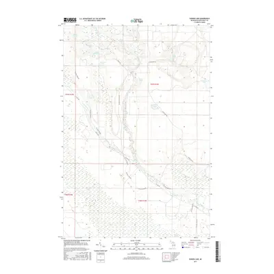
2017 Map of Sunken Lake
USGS Topo · Published 2017About this map
The Little Fox River and the main branch of the Fox River dominate this segment of the Upper Peninsula, creating a complex wetland environment characterized by features like Driggs Marsh and Spring Pond. The landscape is a network of glacial lakes including Sunken Lake, Sucker Lake, and Taylor Lake, many of which are connected by the recreational Fox River Pathway. This trail system follows the corridor of the rivers, providing a modern link through the timberlands and marshes that have long defined Schoolcraft County. Human engineering is visible at Taylor Dam, situated where Wagner Taylor Dam Rd meets the water. The map documents a sparsely populated but ecologically rich area where forestry roads like Sunken Lake Rd and Co Hwy 450 provide the primary access to these remote northern waters.
Find a feature on this map
23 named features on this map. Tap any name to fly to it.
Don’t see what you’re looking for? This feature index may not catch every label — zoom into the map to look around manually.
Map Details
Editions of this 2017 Sunken Lake Map
This is the sole edition of this map. No revisions or reprints were ever made.
Other maps of this area

1931 · Seney SW
USGS Topo · 1:31,680

1931 · Seney NW
USGS Topo · 1:31,680

1931 · Driggs Lake NE
USGS Topo · 1:31,680

1931 · Driggs Lake NW
USGS Topo · 1:31,680

1931 · Driggs Lake SW
USGS Topo · 1:31,680

1931 · Driggs Lake SE
USGS Topo · 1:31,680

1954 · Sault Sainte Marie
USGS Topo · 1:250,000

1956 · Sault Sainte Marie
USGS Topo · 1:250,000

1957 · Sault Sainte Marie
USGS Topo · 1:250,000

1958 · Sault Sainte Marie
USGS Topo · 1:250,000