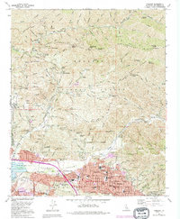
1991 Map of Sunland
USGS Topo · Published 1995About this map
Sunland and Tujunga sit at the base of the Angeles National Forest, where the urban sprawl of the San Fernando Valley meets the sharp ascent of Mendenhall Ridge. This 1991 survey shows a landscape of institutional and residential expansion, featuring the Lakeview Terrace Sanitarium and several educational landmarks such as Mt Gleason Jr H S and Verdugo Hills High Sch. The map documents the critical water infrastructure and debris management systems essential for life at the foot of these mountains, including the Hansen Dam Flood Control Basin and various spreading grounds designed to manage the runoff from Big Tujunga Creek and Little Tujunga Creek. Genealogy researchers will find the Verdugo Hills Cem and Glen Haven Memorial Park clearly delineated. Higher into the forest, isolated outposts like Dillon Ranch and Karl Holton Camp appear alongside names like The Pinnacle and Limerock Peak, indicating the transition from suburban development to the protected wilderness of the national forest.
Find a feature on this map
73 named features on this map. Tap any name to fly to it.
Don’t see what you’re looking for? This feature index may not catch every label — zoom into the map to look around manually.
Map Details
Editions of this 1991 Sunland Map
This is the sole edition of this map. No revisions or reprints were ever made.
Other maps of this area

1894 · Los Angeles
USGS Topo · 1:62,500

1896 · Pasadena
USGS Topo · 1:62,500

1896 · Santa Monica
USGS Topo · 1:62,500

1898 · Santa Monica
USGS Topo · 1:62,500

1900 · Pasadena
USGS Topo · 1:62,500

1900 · Tujunga
USGS Topo · 1:62,500

1900 · Los Angeles
USGS Topo · 1:62,500

1900 · Fernando
USGS Topo · 1:62,500

1901 · Southern California Sheet No. 1
USGS Topo · 1:250,000

1902 · Santa Monica
USGS Topo · 1:62,500