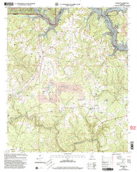
2000 Map of Sunlight
USGS Topo · Published 2003About this map
William B Bankhead National Forest defines the northern reaches of this Walker County landscape, where the Sipsey Fork of the Black Warrior River has been transformed into the sprawling waters of Lewis Smith Lake. The terrain is deeply incised by drainages like Blackwater Creek and Rock Creek, a geography that historically dictated the placement of small communities and rural institutions. Significant land use is marked by numerous Strip Mines that dot the ridges, illustrating the region's industrial connection to coal extraction.
Find a feature on this map
33 named features on this map. Tap any name to fly to it.
Don’t see what you’re looking for? This feature index may not catch every label — zoom into the map to look around manually.
Map Details
Editions of this 2000 Sunlight Map
This is the sole edition of this map. No revisions or reprints were ever made.
Other maps of this area

1893 · Jasper
USGS Topo · 1:125,000

1949 · Cordova
USGS Topo · 1:24,000

1949 · Sipsey
USGS Topo · 1:24,000

1949 · Cold Springs
USGS Topo · 1:24,000

1949 · Jasper
USGS Topo · 1:24,000

1949 · Manchester
USGS Topo · 1:24,000

1949 · Sunlight
USGS Topo · 1:24,000

1950 · Manchester
USGS Topo · 1:24,000

1951 · Jasper
USGS Topo · 1:24,000

1951 · Cold Springs
USGS Topo · 1:24,000