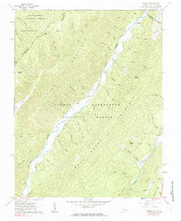
1961 Map of Sunrise
USGS Topo · Published 1984About this map
The Sunrise settlement sits at the heart of this mid-century survey, tucked between the slopes of Little Mountain and the water of Back Creek. The landscape is defined by the overlap of the George Washington National Forest and the Monongahela National Forest, where the state line divides West Virginia and Virginia. The drainages here are complex, with dozens of named runs and hollows such as Sawmill Run, Hacker Run, and Saw Pit Hollow feeding into the main valley. Genealogists will find several family-named landmarks and resting places, including Sively Cem, Lightner Cem, and Boyle Cem. The presence of the Zion Hill Ch and unique localized place names like Fodder House and Chestnut Levels suggest a history of high-country agriculture and logging in this corner of Bath and Highland Counties.
Find a feature on this map
52 named features on this map. Tap any name to fly to it.
Don’t see what you’re looking for? This feature index may not catch every label — zoom into the map to look around manually.
Map Details
Editions of this 1961 Sunrise Map
2 editions found
Other maps of this area

1901 · Monterey
USGS Topo · 1:125,000

1922 · Cass
USGS Topo · 1:48,000

1923 · Warm Springs
USGS Topo · 1:48,000

1924 · Cass
USGS Topo · 1:62,500

1926 · Warm Springs
USGS Topo · 1:62,500

1930 · Warm Springs Run
USGS Topo · 1:24,000

1930 · Mountain Grove
USGS Topo · 1:24,000

1933 · Mountain Grove
USGS Topo · 1:31,680

1933 · Warm Springs Run
USGS Topo · 1:31,680

1941 · Monterey
USGS Topo · 1:62,500