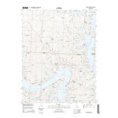
2015 Map of Sunrise Beach
USGS Topo · Published 2015About this map
Lake of the Ozarks dominates the landscape of this 2015 survey, defining the irregular peninsulas and coves of both Morgan and Camden counties. The map illustrates the specialized development around the reservoir, from the residential clusters at Sunrise Beach and the Village of Four Seasons to the small airfields like Bar-Vik Airport and Mistwood Airport that serve the region's recreation-focused economy. In the northern sections, older land use patterns remain visible in the placement of Garber Memorial Cemetery and Silvey Cemetery near the community of Laurie. Local heritage is anchored to the many named inlets and landmarks such as Porter Mill Bend, Sagamo Point, and Folsom Bluff, while the intricate topography is carved by numerous drainages including Brush Creek and Spring Cr.
Find a feature on this map
186 named features on this map. Tap any name to fly to it.
Don’t see what you’re looking for? This feature index may not catch every label — zoom into the map to look around manually.
Map Details
Editions of this 2015 Sunrise Beach Map
This is the sole edition of this map. No revisions or reprints were ever made.
Other maps of this area

1888 · Versailles
USGS Topo · 1:125,000

1893 · Versailles
USGS Topo · 1:125,000

1904 · Eldon
USGS Topo · 1:62,500

1904 · Gravois Mills
USGS Topo · 1:62,500

1932 · Versailles No 4
USGS Topo · 1:48,000

1934 · Camdenton
USGS Topo · 1:24,000

1934 · Purvis
USGS Topo · 1:24,000

1934 · Irontown Ferry
USGS Topo · 1:24,000

1934 · Lake Ozark
USGS Topo · 1:24,000

1934 · Green Bay Terrace
USGS Topo · 1:24,000