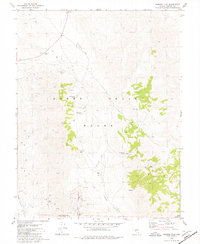
1979 Map of Sunrise Flat
USGS Topo · Published 1980About this map
Gabbs Valley Range dominates this landscape, serving as a hub for mining activity and desert hydrology in the late 1970s. Numerous mining sites are documented throughout the highlands, particularly along the western slopes and near the southern drainage of New York Canyon. The presence of these operations suggests a period of sustained mineral exploration across the rugged terrain, supported by a network of unimproved roads and several Jeep Trails that provided access to the high elevations.
Find a feature on this map
21 named features on this map. Tap any name to fly to it.
Don’t see what you’re looking for? This feature index may not catch every label — zoom into the map to look around manually.
Map Details
Editions of this 1979 Sunrise Flat Map
2 editions found
Other maps of this area

1907 · Tonopah
USGS Topo · 1:250,000

1908 · Tonopah
USGS Topo · 1:250,000

1909 · Hawthorne
USGS Topo · 1:250,000

1911 · Hawthorne
USGS Topo · 1:250,000

1915 · Hawthorne
USGS Topo · 1:250,000

1948 · Walker Lake
USGS Topo · 1:250,000

1956 · Tonopah
USGS Topo · 1:250,000

1957 · Walker Lake
USGS Topo · 1:250,000

1959 · Tonopah
USGS Topo · 1:250,000

1962 · Walker Lake
USGS Topo · 1:250,000