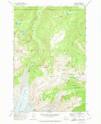
1971 Map of Sunrise
USGS Topo · Published 1974About this map
Mount Rainier National Park dominates this 1971 survey, showing the intricate glacier systems and alpine features of the mountain's northeast flank. The massive Winthrop Glacier and Emmons Glacier carve deep into the terrain, separated by The Wedge. Evidence of early human presence in these high elevations is marked by a Mine at Glacier Basin, while the burgeoning recreational infrastructure of the early 1970s is visible at the Sunrise development.
Find a feature on this map
69 named features on this map. Tap any name to fly to it.
Don’t see what you’re looking for? This feature index may not catch every label — zoom into the map to look around manually.
Map Details
Editions of this 1971 Sunrise Map
2 editions found
Other maps of this area

1913 · Cedar Lake
USGS Topo · 1:125,000

1924 · Mt Rainier
USGS Topo · 1:96,000

1928 · Mt Rainier
USGS Topo · 1:125,000

1950 · Yakima
USGS Topo · 1:250,000

1956 · Greenwater
USGS Topo · 1:62,500

1956 · Enumclaw
USGS Topo · 1:62,500

1957 · Wenatchee
USGS Topo · 1:250,000

1958 · Yakima
USGS Topo · 1:250,000

1961 · Yakima
USGS Topo · 1:250,000
1971 · White River Park
USGS Topo · 1:24,000