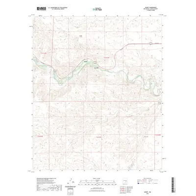
2023 Map of Sunset
USGS Topo · Published 2023About this map
Rio Hondo carves a central path through this Lincoln County landscape, serving as the primary drainage and historical corridor for local movement. The small settlements of Sunset and Riverside are positioned along this waterway, where the valley floor provides a break from the surrounding upland topography. Much of the activity is centered along Co Rd E022, which follows the river's course, connecting these small communities. The terrain is defined by significant geographical markers such as Border Canyon to the north and Border Hill to the southeast, while Bonney Canyon marks the eastern edge of the survey. The mapping of township lines like t11s r19e and t12s r19e illustrates the underlying cadastral framework that governs this rural New Mexico territory.
Find a feature on this map
12 named features on this map. Tap any name to fly to it.
Don’t see what you’re looking for? This feature index may not catch every label — zoom into the map to look around manually.
Map Details
Editions of this 2023 Sunset Map
This is the sole edition of this map. No revisions or reprints were ever made.
Other maps of this area

1955 · Roswell
USGS Topo · 1:250,000

1958 · Roswell
USGS Topo · 1:250,000

1961 · Flying H
USGS Topo · 1:62,500

1961 · Indian Bluff
USGS Topo · 1:62,500

1961 · Tinnie
USGS Topo · 1:62,500

1962 · Roswell
USGS Topo · 1:250,000

1962 · Horseshoe Bend
USGS Topo · 1:62,500

1979 · Roswell
USGS Topo · 1:100,000

1984 · Ruidoso
USGS Topo · 1:100,000
1988 · Nelson Canyon East
USGS Topo · 1:24,000