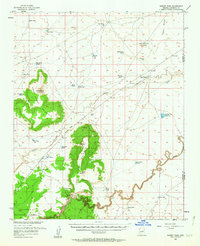
1955 Map of Sunset Pass
USGS Topo · Published 1963About this map
West Sunset Mountain and East Sunset Mountain dominate this mid-century Coconino County landscape, separated by the strategic corridor of Sunset Pass. The survey, completed in cooperation with the Atomic Energy Commission, reflects a rugged High Desert environment defined by water management and ranching infrastructure. Numerous named water catchments like Porcupine Tank, Hobo Tank, and Rowlan Tank are scattered throughout the territory, illustrating the essential nature of water storage for livestock and local operations. The winding course of Clear Creek carves through the southern portion of the sheet, while Jacks Canyon cuts across the central plains. This 1950s record provides a look at the arid periphery of the Coconino National Forest, where the presence of the Winslow Municipal Well Field and several prospect pits indicate the ongoing industrial and municipal utility of the land during the atomic era.
Find a feature on this map
30 named features on this map. Tap any name to fly to it.
Don’t see what you’re looking for? This feature index may not catch every label — zoom into the map to look around manually.
Map Details
Editions of this 1955 Sunset Pass Map
2 editions found

Other maps of this area

1883 · Tusayan
USGS Topo · 1:250,000

1886 · Tusayan
USGS Topo · 1:250,000

1886 · San Francisco Mtns
USGS Topo · 1:250,000

1886 · Holbrook
USGS Topo · 1:250,000

1887 · Verde
USGS Topo · 1:250,000

1891 · San Francisco Mtns
USGS Topo · 1:250,000

1892 · Verde
USGS Topo · 1:250,000

1893 · Holbrook
USGS Topo · 1:250,000

1894 · San Francisco Mtns
USGS Topo · 1:250,000

1899 · San Francisco Mtns
USGS Topo · 1:250,000